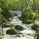
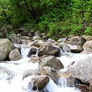
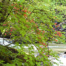
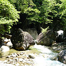
Kamasegawa River, Kuromori

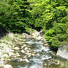
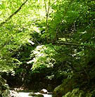
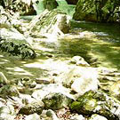
Hondanigawa River, Masutomi

amago mark


Upstream Kamasegawa Riv.
Shiokawa map
Hondani Kamase Ichigo Bridge's neighborhood

Kamasegawa River and Hondanigawa River joins at Shiokawa dam. The lower part of the stream from here is called Shiokawa River. Kamasegawa River comes from Mt. Mizugaki (2230m) and Hondanigawa River comes from Mt. Kinpuzan (2595m).
Kamasegawa River has two face that are light quiet stream of Kuromori area and precipitous upper stream. Hondanigawa River has deep valley that is called Tsusenkyo and quiet stream that runs through the forest of maple and Japanese oak to the headstream from Masutomi mineral spring. To enter river from road is easy both except precipitous area.
To go to Kuromori or Masutomi it take about one hour with prefecture route 23 from Sutama IC of Chuo expressway. This area is located in the west side of Chichibu Tama Kai National park, and I could enjoy comfortable fishing into unsophisticated beautiful nature.
If you take its route to the left direction at Kuromori you can arrive to Kawakami village Nagano prefecture through Shinshu mountain pass. This route was an important point to link Nagano and Yamanashi in the Period of War, and Masutomi mineral spring was discovered when The samurai / Shingen Takeda dug gold. It is attractive area that can enjoy trout fishing and a mineral spring at a time.
Hikage's neighborhood
Azalea and Stream
Upstream Hondanigawa Riv.
Masutomi Mineral Spring's neighborhood
Upstream Hondanigawa Riv.
Amago of perfect appearance


My Best Streams
Flies
Equipment


amago Profile Link Home
Back to Main Home Page Profile Links
Home


Paper Trout
Paper Craft of Japanese Trout and the World Trout


Pencil
Please look at here if you are interested in ordering pictures.


© 1997 Yoshikazu Fujioka